Systematic, science-based conservation planning is a hallmark of the Conservancy. For biodiversity to thrive, habitats need to be protected, enhanced, or restored not just in the still wild places on the planet but also where people live and make their livelihoods.
Multi-disciplinary planning can help elucidate where the highest priority places are and what needs to happen there – and inform tradeoffs between conservation and other societal values.
The Nature Conservancy: Erica Brand, Laura Crane, Dick Cameron, Energy and Environmental Economics: Grace C. Wu, Nick Schlag
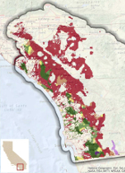
Integrating ecological data into long-term energy planning is critical to meet both California’s long term energy and conservation goals. This report assesses the potential trade-offs associated…
M.G. Anderson, P.J. Comer, P. Beier, J.J. Lawler, C.A. Schloss, S. Buttrick, C. M. Albano, D. P. Faith
Incorporating geodiversity into conservation plans to ensure conservation actions are more resilient to climate change is appealing because it addresses the threat of climate change while avoiding the…
Patrick J. Comer, Robert L. Pressey, Malcolm L. Hunter Jr., Carrie A. Schloss, Steven C. Buttrick, Nicole E. Heller, John M. Tirpak, Daniel P. Faith, Molly S. Cross, Mark L. Shaffer
The protection of biodiversity in a changing climate is a key challenge for conservation planners. Conserving a diversity of geophysical settings makes species and systems more resilient to climate…
Tamara S. Wilson, Jason Sherba, Dick Cameron, Benjamin M Sleeter
Human land use will increasingly contribute to habitat loss and water shortages in California, given future population projections and associated land-use demand. Understanding how land-use change may…
Miriam Tsalyuk, Maggi Kelly, Kevin Koy, Wayne M. Getz, H. Scott Butterfield
Monitoring the effects of grazing on rangelands is crucial for ensuring sustainable rangeland ecosystem function and maintaining conservation values. Residual dry matter (RDM), the dry grass…
Doak, D.F., G.K. Himes Boor, V.J. Bakker, W.F. Morris, A. Louthan, S.A. Morrison, A. Stanley, L. Crowder
One of the key components of a recovery plan for a threatened or endangered species in the United States is the set of recovery criteria that will be used to evaluate progress in abating the threats…
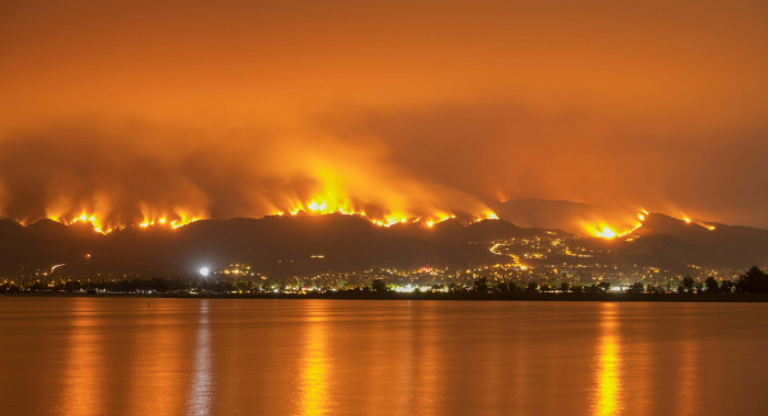
M.L. Mann, P. Berck, M.A. Moritz, E. Batllori, J.G. Baldwin, C.K. Gately, D.R. Cameron
Between 1940 and 2000, nearly 10 million housing units were constructed in California. This new development led to increased interaction between human and natural communities. Tha authors of this…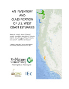
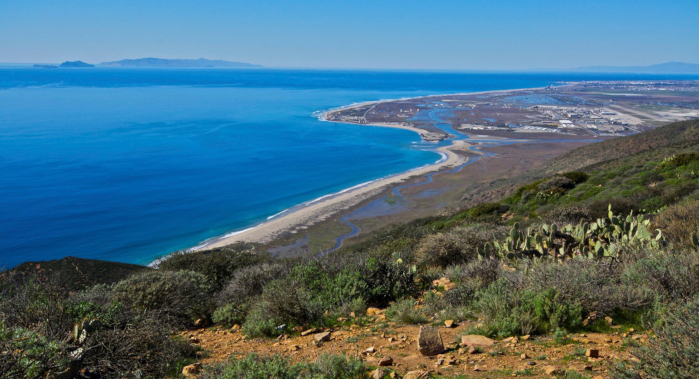
Walter N. Heady, Kevin O'Connor, Jennifer Kassakian , Kate Doiron, Charles Endris, Daniel Hudgens, Ross P. Clark , Jena Carter , Mary G. Gleason
Estuaries are some of the most productive ecosystems on the planet. This inventory classifies more than 600 coastal confluences on the West Coast of the United States. Each estuary was classified…
Matt Miller, Dick Cameron
Cameron DR, Marty J, Holland RF
This study assesses the amount of rangeland conversion between 1984 and 2008 in California. The researchers analyzed data from the California Farmland Mapping and Monitoring Program to see where…
B. C. Mclaughlin, C. N. Morozumi, J. MacKenzie, A. Cole, S. Gennet
Anticipating how species will move as the climate changes is a fundamental concern in 21st century conservation. This study modeled potential responses of blue oak (Quercus douglasii), an…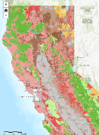
Michelle D Staudinger, Shawn L Carter, Molly S Cross, Natalie S Dubois, J Emmett Duffy, Carolyn Enquist, Roger Griffis, Jessica J Hellmann, Joshua J Lawler, John O'Leary, Scott A Morrison, Lesley Sneddon, Bruce A Stein, Laura M Thompson, Woody Turner
This paper synthesizes research pertaining to climate change impacts on biodiversity, reviewed by the biodiversity technical working group of the 2014 National Climate Assessment. The paper focuses on…
Golet G.H., D.L. Brown, M. Carlson, T. Gardali, A. Henderson, K.D. Holl, C.A. Howell, M. Holyoak, J. Hunt, G.M. Kondolf, E.W. Larsen, R.A. Luster, C. McClain, C. Nelson, S. Paine, W. Rainey, Z. Rubin, F. Shilling, J.G. Silveira, H. Swagerty, N.M. Williams, D.M. Wood
Large-scale ecosystem restoration projects seldom undergo comprehensive evaluation to determine project effectiveness. Consequently, there are missed opportunities for learning and strategy…
Principe, Z., J.B. MacKenzie, B. Cohen, J.M. Randall, W. Tippets, T. Smith, S.A. Morrison
Coastal southern California has long been the focus of regional conservation planning efforts. Decades ago – and prior to today’s heightened awareness of the magnitude of the likely…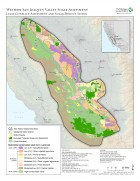
Butterfield, H.S., D. Cameron, E. Brand, M. Webb, E. Forsburg, M. Kramer, E. O’Donoghue, L. Crane
The Western San Joaquin Valley Least Conflict Solar Energy Assessment characterizes the land use constraints and opportunities associated with siting solar energy facilities in the Western San Joaquin…
Butterfield, H.S., D. Cameron, E. Brand, M. Webb, E. Forsburg, M. Kramer, E. O’Donoghue, L. Crane
A Conservancy analysis of the western Mojave Desert identified where human activities had degraded the conservation value of lands making them potentially low impact locations for development of solar…